Wednesday, May 22, 2013

ANOTHER TABUR STORY


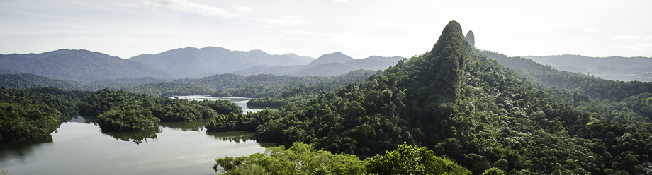
Although this trail is called the East trail, this trail is far more difficult and more dangerous compared to the Extreme trail. Being the most difficult among all four peaks of Bukit Tabur, the East trail is the least popular trail among occasional hikers.
The East trail starts somewhere near a village in Taman Melawati, which is very close by to a new, eccentric housing area which I cannot recall its name, LOL.
We walked pass a water pipe which led us to an ascending thick jungle. A few metres up and we came across our first rope action. There were a few more ropes before we reached the first viewing point.

READ THE REST OF THE STORY HERE


another interesting and informative link here


TABUR PHOTOGRAPHY


We finally set off for the Tabur (West) hike after the trip having been postponed from the weekend before. Bukit Tabur is a limestone ridge, that is also known as 'The Dragon Backbone', located at Taman Melawati in Kuala Lumpur. It is apparently the longest crystal quartz outcrop in the world that  boasts a wide range of flora and fauna, including langurs. I didn't actually see any langurs during the hike itself but definitely heard all the commotion that they were making! Tabur has several peaks that can be traversed but the trail for the more popular West route starts on the left side of the road (coming from KL) near the Klang Gates entrance.  
The Dragon Backbone
The Dragon Backbone
The windy road up to the start of the trek would be hard to find if one does not know exactly how to get there. We didn't have any problems finding the place as Andy had done some reconnoitring prior to the trip. The proximity of the route was also made fairly obvious by the presence of the numerous cars found parked at the side of the narrow road, although this made parking a little tedious. We finally found a parking spot down the road and once the car was tucked into the side of the road safe & sound from oncoming traffic, we made our way back up the road to the start of the route (Point A, coordinates are '3.233921, 101.749046').


Interesting write up on tabur .full story here