Tuesday, December 1, 2015

TABUR EXTREME


A hike organised for the nature explorers(kl) meet up group .

November 29th 2015. About 16 hikers from the meet up group Nature explorers(kl) to explore Tabur Extreme from the kemensah side(behind the National zoo)We met up at Deen's restaurant at Taman Melawati at 6.30am for breakfast. Even though it started raining , and some of the hikers we worried and asked if we will still proceed with our plan. We told them we will. We headed to the trail head behind the zoo, parked our cars. We had arrange to car pooled due to limited parking at that area. When we reached there, there were already many cars parked and we have to park by the roadside. As we started to climb, the rain stopped, which was a welcome. However the ground was still muddy, due to continued rain the past few days and it was made worst by the Atv activities. Here are some of the photos taken during the hike.


Our regular water melon supplier.Watermelon Lau.


Photo credit:TS Ng


photocredit: Ts Ng


photo credit:Michael Ong

Picking up rubbish left by irresponsible hikers.

Tuesday, November 24, 2015

In a Nutshell: Bukit Ketumbar

In a Nutshell: Bukit Ketumbar


Nice write up. It's been a long while since I have been here. Hope to revisit soon.


In a Nutshell: XPDC Bukit Batu Gajah aka Tabur Extra

In a Nutshell: XPDC Bukit Batu Gajah aka Tabur Extra


Where is this? I have been to all four Taburs but have never heard of this name until now. Must find out where the actual entrance is.


arrow pointing upwards is the "false peak"which they dubbed as extra. Arrow pointing to the right is the trail to Tabur Extreme.


close up photo of the sign pointing to Tabur extreme.


Thursday, July 9, 2015

TABUR FAR EAST/EXTREME


Category : HikingLifestylePhotography · by Mar 24th, 2013
Heard of Tabur Far East for quite a while, been told by friend that it is a trail that full of nice scenes. The trail is less common compares to normal East/ West Tabur and starting point is totally different too. Have been waiting to join-in those that familar with the route, then finally i got this chance by follow G3 Hikers to both Far East and the Extreme trails on Sunday, 17th March.
Starting point and place to park we park our car at Jalan K5, near by Jalan Melawati 5 at a new upper hill high-price house development area named “Sunway Rydgeway“. Currently still able to park at road side, but doubt we can still park at same place once the housing area completed.
There are more development area to passed by after Sunway Rydgeway which will take 5-8 minutes to the beginning of Far East and Extreme trail.
After construction area, you will passed by the gate, it is a “private” area that contain few wood houses with lots of dogs locked inside.
This will be entrance to the forest trail, another 15 to 20mnutes minutes walk will bring you to a joint of Tabur Far East and Tabur Extreme. The two trails will be separte from there and form a T shape as seen (yellow color route) at this map. Once completed one of those trails, you will come back to the joint in order to start another one.
Such soft plant can be easily seen along the Far East trail, and lots of mosquitos at this point where the ridge walk begin! It will be a better choice to wear long pants and long sleeves to avoid attack from these blood suckers, the mosquitos will be gone when hike-up to higher altitude.
Wheather is extremly well on the day, strong sun light helps to push a better image even from a Pentax DA 18-55mm F3.5-5.6 AL Kit lens. Group picture was taken on a spacious soft-ground rest point that located on half way to Far East’s peak and those cards are the symbol/logo of G3 hikers.
View from Far East peak, ridge opposite in the image above is normal Tabur East (normal) according to experienced hiker in our group. So, i assume the sequences of the ridge connection is: West -> East -> Far East -> Extreme.
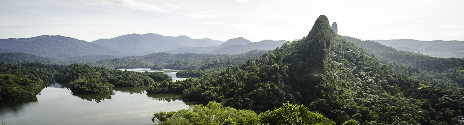
The Panoramic view from Far East is far more richer compares to Tabur West, where you can get the picture of Tabur East, a more complete vision of the lake and part of Tabur Extreme (X). Video below was taken on Far East Peak where you can see hikers on the other side, peak of Tabur East (normal).

After completed Tabur Far East trail, we went back to the “T junction” for a rest and get prepare for Tabur Extreme trail which is a more difficult trail to trek.
It surprised me when i discover Extreme trail is rather virgin compares to other Tabur trails, path is not obvious with only few hardly seen route sign/marks. Lots of sharp thorns and long roots that will hurt you along the path, moreover, the dangerous soft-ground that may collapse if step-in with full weight pressure.
The giant rock as image above is where Extreme’s peak situated, but we have trek around the left side of foot hill, to the back side of it before the climb starts, where it took around 50 minutes from “T junction” according to recorded movescount.
A little bit of rock climbing are required, thanks to great hikers that equipped steady rope up there, it makes the climb much more easier. Took another 15 – 20 minutes to first peak, there will be total of 4 peaks that we need to go repeating up and down. Tabur Extreme is actually a “U” shaped trail, where we trek from front to the back of the giant rock and move back to top-end of giant rock as the previous image above.
Experienced a minor heat stroke while at the peak of Tabur Extreme, symptoms where i find hard to breath, food in-take difficulty, body stay in a high temperature and losing strength. Immediately unstrap heart rate monitor, loose up backpack, gloves and tights to get more room for fresh air. Got to thanks sweeper of G3 hikers that let me take my time to rest in multiple points, luckily able managed to finished the whole trail with slow pace and this will definitely be one of my great experience.
Video below took on the peak of Extreme peak, where you can spot both far east and normal east peak.

Recorded Trail from Suunto Ambit:
  • GPX format: Tabur Far East and Extreme
  • KML format: Tabur Far East and Extreme
  • Movescount: move11727043
  • Start Point and Car Parking as the blue marker below,

    View Tabur Far East in a larger map
  • original story here  Credit: Kampung toys, and Bear Lew
  • Tuesday, September 17, 2013

    Klang Gates Quartz Ridge

    Klang Gates Quartz Ridge Expedition (East Ridge only) - 23rd April 2011

    April 24, 2011 at 10:29pm
    All the previous Tabur events have finally culminated into this expedition. Thanks and no thanks to the weather that day; thanks because it let us complete the entire East Ridge, no thanks for discouraging us from doing the West, and pelted us with thunderstorm and lightnings. The East Ridge was the priority due to many awesome peaks and moss carpets(Photo 1 below).

    This trip was part of our Earth Day (22nd April) celebration, although it didn't happen on the exact date, which was a working day.


    Photo 1: Moss carpet at Far East
    Photo 1: Moss carpet at Far East


    I have been to Tabur West few years back. Tabur wasn't really my kind of hills for a couple of reasons -- not hardcore enough and the torturing temperature under the sun. Thanks to MNS Pathfinders' vigour-always-in-him Chris Leo, I got to check out one of the most beautiful Tabur peaks i.e. Tabur Far East (http://goo.gl/eKYob). The journey is itself impeccably beautiful, as we walked through a private area which I called the Secret Garden(Photo 2 below). To date, it remains accessible.

    Photo 2: Secret Garden
    Photo 2: Secret Garden


    Two reasons prompted us to do the expedition:
    Before KLORR becomes visible (more below), and disrupts the natural beauty of the ridge and contrasts it with marvels of modern construction; and a complete traverse of all peaks as a matter of personal challenge, not solely "because they are there", as the famous saying goes.

    Short chronology:
    Jan 29: I joined MNS Pathfinder to hike Tabur FE. Like I have mentioned earlier, Tabur does not excite me. Reflecting back, I joined because I have not met Chris for a long time, and I thought that was a good time to catch up. Chris also introduced the initial part of the trail heading up to Extreme. That was not part of his event programme; but did so after a few of us indicated our interests to check it out, so we got to the wind passage just before the huge vertical rock wall (Photo 3 below).

    Shortly after, the recce team was formed with me, Kin Hou, Chiu Wah and Peter Lau. We maintained the principle that all the recce trips till final expedition will be done by this team, all or none. The prerequisites to complete the expedition are the Extreme/Far East and Far East/East trails.


    Photo 3: Tabur Extreme's vertical wall
    Photo 3: Tabur Extreme's vertical wall


    Feb 6: With the knowledge of Far East trail, we decided to recce up Extreme. Not successful. The guide posted in the blog by the previous group is no longer usable; the terrain has altered after so many moons. We did not turn back on the same 'paper' trail hoping that by going further away may lead us to another trail up. Nope, that didn't work out! After walking under the scorching sun and passing Orang Asli settlement, we ended up in Kemensah area, far from where we parked our cars near the trailhead. We walked a very long distance on this day.

    Feb 19: Second recce. This round, Chiu Wah tied (donated) a used dynamic rope at the top after a narrow gap of two rock walls; we knew we will come back one day to complete this. We bulldozed through the large fern patch from the last successful point after the rope. We reached the top (but before the peak) in less than a hundred metres (Figure 1 below). Unfortunately, we did not lay tape markers for this last stretch (Photo 4 below). On the return journey, we took a bypass this round and walked a shorter distance (but still under the same "solar power" intensity) to a construction area in Tropika Kemensah; there, we had a car already parked there before the recce as part of our logistics planning.

    Photo 4: This 'ghostly' tree marks the junction of Far East / Extreme trail.
    Photo 4: This 'ghostly' tree marks the junction of Far East / Extreme trail.

    Figure 1: Tabur Extreme GPS track.
    Figure 1: Tabur Extreme GPS track.


    Apr 2:  This recce covers from FE to East (the final gap) and once again we threaded an entirely different path; that was after we hiked up all the peaks leading to the deep ravine(Figure 2 below). This recce was a success!

    Figure 2: Tabur Far East to East GPS track.
    Figure 2: Tabur Far East to East GPS track.


    Apr 23: Klang Gates Quartz Ridge Expedition -- East Ridge only (Figure 3  below). Trip managed to join us but not Captain Ng who has to attend his Wataniah event in Shah Alam.

    Photo 5: The expedition team. From left: Kin Hou, Peter Lau, Triptipal Singh, Yours Truly, Chiu Wah.
    Photo 5: The expedition team. From left: Kin Hou, Peter Lau, Triptipal Singh, Yours Truly, Chiu Wah.

    Figure 3: The complete GPS track for East Ridge.
    Figure 3: The complete GPS track for East Ridge.


    Two impediments halted us from continuing to the West Ridge: (1) The weather as described at the beginning, and (2) There is no continuous nature-type traverse across from the East to the West Ridge. The second reason is particularly demotivating as we wanted to do an end-to-end expedition completely on nature trail but which we knew this is not possible. That gap is simply a disconnect!

    The day trip took us seven hours of leisurely hike and rest, and photography, with a traveled distance of about 6 km (Figure 4 below).

    Figure 4: The elevation profile of East Ridge
    Figure 4: The elevation profile of East Ridge


    This earlier incoming storm did not hit us (Photo 6 below).

    Photo 6: Incoming storm heading another direction
    Photo 6: Incoming storm heading another direction


    Bit of Background:
    The entire ridge has a total length of up to 14 km and a width of up to 200 metres wide (Dr Ibrahim Komoo and Dr Syafrina Ismail in The Geotope of Klang Gates Quartz Ridge, Selangor, undated: http://www.ukm.my/wgm/pdf/2abstrak.pdf). The distance I plotted on Wikimapia gave ~ 12 km (Figure 5 below). Of course, this is just my research/findings without any scientific basis. Also, Dr Ibrahim mentioned that the development over the years that eroded parts of the ridge, as described by Michael Cheang inhttp://mcleon.tripod.com/quartz-ridge.htm.

    Figure 5: The length of the quartz ridge
    Figure 5: The length of the quartz ridge


    About KLORR:
    KLORR is KL Outer Ring Road which connects from Rawang to Cheras (see image 1 below), cutting thru you-know-where. We do not know how much "devastation" the construction will create and nature space taken off the map, so part of the reason for our expedition is to document the "before" scenes; and to ensure we traveled the entire ridge before parts of it, if any, are closed for access. More about it at The Star Online (titled "Path to destruction"): http://goo.gl/wfDgp.


    source: The Star Online

Note the path of planned construction.
    source: The Star Online Note the path of planned construction.


    Last but not least, thanks to my recce teammates Chiu Wah, Kin Hou and Peter. We were glad to have Triptipal with us too. Also thanks to Chris Leo who re-opened my eyes on Tabur!

    To whoever who wants to do a trip there, may this note help...

    Metta

    Footnote: this post reproduced here with permission from Jimmy oddstuff chew.
    Thanks Jimmy for allowing me to share out.

    Wednesday, May 22, 2013

    ANOTHER TABUR STORY


    Although this trail is called the East trail, this trail is far more difficult and more dangerous compared to the Extreme trail. Being the most difficult among all four peaks of Bukit Tabur, the East trail is the least popular trail among occasional hikers.
    The East trail starts somewhere near a village in Taman Melawati, which is very close by to a new, eccentric housing area which I cannot recall its name, LOL.
    We walked pass a water pipe which led us to an ascending thick jungle. A few metres up and we came across our first rope action. There were a few more ropes before we reached the first viewing point.

    READ THE REST OF THE STORY HERE


    another interesting and informative link here


    TABUR PHOTOGRAPHY


    We finally set off for the Tabur (West) hike after the trip having been postponed from the weekend before. Bukit Tabur is a limestone ridge, that is also known as 'The Dragon Backbone', located at Taman Melawati in Kuala Lumpur. It is apparently the longest crystal quartz outcrop in the world that  boasts a wide range of flora and fauna, including langurs. I didn't actually see any langurs during the hike itself but definitely heard all the commotion that they were making! Tabur has several peaks that can be traversed but the trail for the more popular West route starts on the left side of the road (coming from KL) near the Klang Gates entrance.  
    The Dragon Backbone
    The Dragon Backbone
    The windy road up to the start of the trek would be hard to find if one does not know exactly how to get there. We didn't have any problems finding the place as Andy had done some reconnoitring prior to the trip. The proximity of the route was also made fairly obvious by the presence of the numerous cars found parked at the side of the narrow road, although this made parking a little tedious. We finally found a parking spot down the road and once the car was tucked into the side of the road safe & sound from oncoming traffic, we made our way back up the road to the start of the route (Point A, coordinates are '3.233921, 101.749046').


    Interesting write up on tabur .full story here